Can a Satellite Camera Be Geared Toward Urban Planning?
Think of yourself as snarled up in a traffic gridlock that never ends. You look around to see a sprawling cityscape, chaotic and unorganized. Unplanned buildings have sprouted up, parks have dwindled, and green spaces are all but a dream. As an urban resident, the tangible consequences of inefficient urban planning are all too real. The tip of the iceberg pertains to issues like congestion, overcrowding, and declining quality of life.
But what if there was a method to plan our cities properly? To reduce congestion, optimize land use, and create a more sustainable urban environment? This is where the eye in the sky, the satellite camera, comes into play.
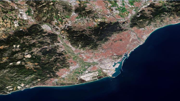
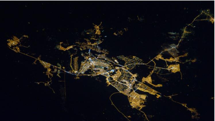
A bird’s eye view of our world is provided by satellite cameras circling hundreds of miles above the surface. A network of these “eyes” provides continuous data, revealing patterns and trends that are invisible from the ground.
The Power of Satellite Cameras
Remember when satellite camera technology was just getting started? It was an era when the mere thought of using a camera that orbited our planet seemed to be a plot lifted from a science fiction novel. The satellite camera has developed through time, going from being primarily utilized for scientific study and military surveillance to being an essential instrument in a wide range of commercial applications.
One such application where satellite cameras show immense potential is urban planning. But what exactly makes these “eyes in the sky” so ideal for city planning? The answer lies in their exceptional capabilities.
A satellite camera offers a thorough, bird’s-eye perspective of the world below, just like an eagle swooping high above the ground. This viewpoint is especially helpful when developing an urban area to lessen air pollution, control traffic, and monitor land-use changes.
The eagle’s vision is renowned for its sharpness and accuracy; similarly, satellite cameras equipped with high-resolution sensors can capture imagery with unparalleled precision. This enables city planners to analyze patterns of urban development, land usage, and environmental impact, which are vital data points for devising sustainable urban strategies.
In essence, the satellite camera uses its eagle-like vision to make urban planning more efficient, helping us build sustainable cities where congestion is minimized, the land is optimally used, and air quality is improved.
Satellite Cameras and Urban Planning: An Ideal Union
“What is a satellite camera?” you may ask. Imagine a photographer perched in space, snapping high-definition pictures of our planet. That’s what a satellite camera does. But these cameras are more than mere photographers. They are information powerhouses that can deliver accurate, up-to-the-minute data on the earth’s surface.
And what is the resolution of satellite cameras? The resolution can range from a meter to tens of centimetres, depending on the kind of satellite. This means they can detect even small changes in land usage or city development with incredible precision.
But how do urban planners use remote sensing data from these cameras? Let’s look at a few examples to illustrate the ideal union between satellite cameras and urban planning.
Take the case of Singapore, a city-state grappling with the challenge of urban sprawl. Singapore’s Urban Redevelopment Authority utilizes satellite camera data to manage its growth. They monitor urban development and land use changes in real-time, helping them plan infrastructure effectively and ensuring that growth doesn’t come at the expense of green spaces.
Similarly, Los Angeles, a city known for its infamous traffic congestion, employs satellite camera data for traffic management. Detailed aerial imagery helps officials identify traffic patterns and hotspots of congestion and plan transportation systems to alleviate these issues.
In Rotterdam, satellite camera imagery is used to plan flood defence systems, a crucial part of city planning for a location largely below sea level. The city can plan and react swiftly to prevent flooding by monitoring sea levels and precipitation.
These case studies underscore the immense potential of satellite cameras for urban planning.
Potential Challenges and Solutions
Harnessing the power of satellite cameras for urban planning has its obstacles. There are two primary challenges that city planners face: privacy concerns and the requirement of technical knowledge to interpret satellite data.
In the digital age, privacy is paramount. With the resolution of satellite cameras improving, the question of “Which satellite image is suitable for urban planning?” often arises. While high-resolution images may offer detailed insights for urban planning, they also raise concerns about privacy infringement. There’s a fine line between using satellite cameras for the common good and infringing on individual privacy.
The second challenge lies in the realm of technicality. It takes skill to interpret satellite data, which is a challenging undertaking. With a sound understanding of remote sensing techniques, the rich data from satellite cameras can be manageable to decipher and use effectively.
These difficulties call for a combination of regulation, technology, and education.
Privacy concerns can be addressed through strict regulation. Policies must be established to define the limit of data use and protect individuals’ privacy rights. It’s about balancing gathering necessary data for urban planning and respecting privacy.
As for the technical challenge, education plays a crucial role. Training programs can equip urban planners with the knowledge to interpret and use satellite data. Developing user-friendly software that simplifies data interpretation can make the technology more accessible.
While satellite camera technology holds vast potential for revolutionizing urban planning, its effective use lies in how well we can navigate its challenges.
Final Thoughts
As we’ve seen, the potential of satellite cameras in revolutionizing urban planning is vast. These celestial photographers, capable of capturing high-resolution, real-time imagery, can provide invaluable insights into land use, traffic patterns, and environmental impact. They allow us to view our cities uniquely, enabling urban planners to design smarter, more sustainable urban environments.
But what does the future hold? Picture a world where urban planning isn’t just about constructing buildings and roads and shaping cities that breathe, grow, and evolve sustainably. A world where satellite cameras become the indispensable tool in every urban planner’s kit, where data from the skies guides us in crafting cities that harmonize with their natural surroundings.
A question arises as we stand at this exciting crossroads of technology and urban planning. How comfortable are you with satellite cameras playing a pivotal role in shaping your city’s future? Would you welcome the bird’s-eye view in designing the blueprint of your city life, or do you harbour reservations? As dwellers of these cities, your perspectives are crucial in this conversation.